Pha Daeng Fm
Type Locality and Naming
Synonym: หมวดหินผาแดง
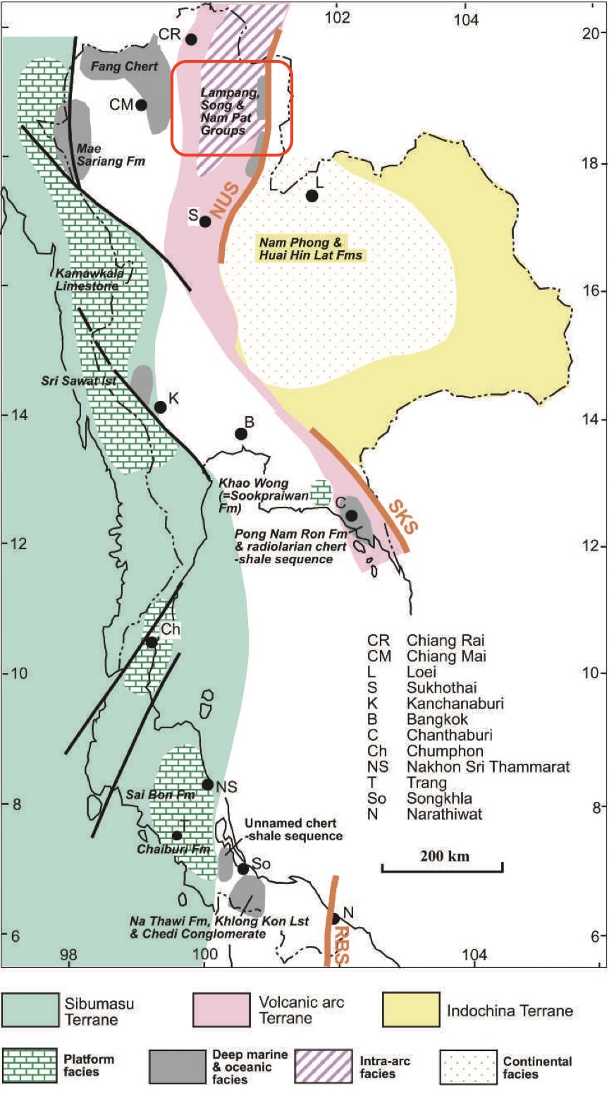
[Figure 1 : Generalized distribution of different Triassic sedimentary environments and some of the more important lithostratigraphic units, and their relations to the terranes. (The geology of Thailand, 2011) page 146]
Lithology and Thickness
Predominantly red shale, sandstone and conglomerate. Limestone-clast conglomerate occurs at the lower part of the formation and changes upward to red beds. Thickness: 600 m (Chonglakmani, 1981), 700 m at Doi Pha Daeng-Huai Ting Tue section (Chaodumrong, 1992)
Relationships and Distribution
Lower contact
Upper contact
GeoJSON
Fossils
Age
Depositional setting
Additional Information
Synonym: หมวดหินผาแดง
[Figure 1 : Generalized distribution of different Triassic sedimentary environments and some of the more important lithostratigraphic units, and their relations to the terranes. (The geology of Thailand, 2011) page 146]
Lithology and Thickness: Sandy_claystone
Predominantly red shale, sandstone and conglomerate. Limestone-clast conglomerate occurs at the lower part of the formation and changes upward to red beds. Thickness: 600 m (Chonglakmani, 1981), 700 m at Doi Pha Daeng-Huai Ting Tue section (Chaodumrong, 1992)
Lithology-pattern: Sandy_claystone
Relationships and Distribution:
Lower contact: Underlain by the uppermost unit (Doi Long Fm) of the Lampang Gr.
Upper contact: Kang Pla Fm (conformable) or Wang Chin Fm (unconformable)
Regional extent: Extends locally into the Lampang Sub-basin, west part of the Northern Region of Sukhothai Fold Belt.
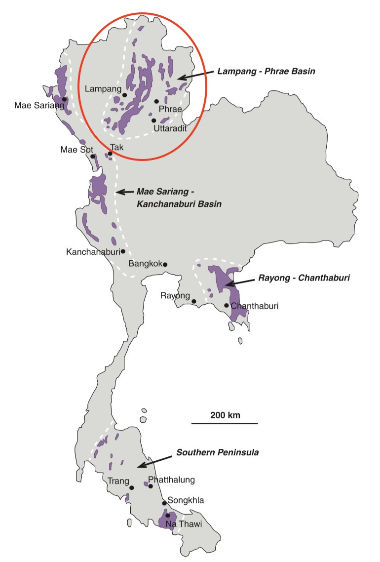
[Figure 2 : Generalized distribution of marine Triassic sedimentary rocks in Thailand (in purple) (modified after Mantajit 1999). (The geology of Thailand, 2011) page 138]
GeoJSON: { "type": "Feature", "properties": { "NAME": "Sukhothai Zone" }, "geometry": { "type": "MultiPolygon", "coordinates": [ [ [ [ 99.59, 20.42 ], [ 99.77, 20.62 ], [ 100.02, 20.62 ], [ 100.29, 20.58 ], [ 100.56, 20.32 ], [ 100.65, 20.21 ], [ 100.86, 20.03 ], [ 100.99, 19.79 ], [ 101.06, 19.55 ], [ 101.01, 18.73 ], [ 100.44, 17.98 ], [ 100.3, 17.46 ], [ 100.3, 17.2 ], [ 100.08, 17.12 ], [ 99.93, 16.92 ], [ 99.9, 16.86 ], [ 99.64, 16.65 ], [ 99.6, 16.65 ], [ 99.3, 16.91 ], [ 98.84, 17.53 ], [ 98.8, 17.99 ], [ 98.9, 18.74 ], [ 99.29, 19.31 ], [ 99.59, 20.42 ] ] ] ] } }
Fossils: A greyish argillaceous limestone immediately above the limestone conglomerate includes a bed containing Trigonodus, indicating a Middle Carnian age (Chonglakmani & Grant-Mackie 1993). In the Phrae Sub-basin the Pha Daeng Formation consists of shallow-marine red to grey sandstones and shales. These strata contain bivalves and ammonoids, for example, Halobia styriaca, H. cassiana, Anatomites sp. and Griesbachites sp.
Age: ca. early-Middle Carnian in Fig. 6.2 of Chonglakmani, C.P., 2011. Detrital zircons give ages of 226±3, 227±4 and 229±3 Ma (Burrett et al.).
Age span:
Beginning stage: Carnian
Fraction up in beginning stage: 0.3
Beginning date (Ma):
Ending stage: Carnian
Fraction up in ending stage: 0.5
Ending date (Ma):
Depositional setting: Fan delta deposits (Chaodumrong, 1992), continental deposits (Piyasin, 1971; Chonglakmani, 2011)
Depositional-pattern:
Additional Information
Remarks: This formation was previously mapped as the uppermost unit of the Lampang Gr (Piyasin, 1971). Chonglakmani (1981, 2011) regarded it as separate formation under the Song Gr. However, the Pha Daeng Fm lies conformably on the Doi Long Fm. With respect to the international stratigraphic guide’s, priority rule, the Pha Daeng Fm belongs to the Lampang Gr.

